Growing up in Council Bluffs, Iowa, as I did, you become acutely aware of two things: the Missouri River and the history of Lewis and Clark. As any Council Bluffs third grader can tell you, Lewis and Clark, the famed explorers of the early 19th Century, named Council Bluffs because they had a meeting with some Indians on the bluffs which overlook the Missouri River.
Council Bluffs returned the favor by naming a grade school after them, which I graced with my presence from first through fifth grades.
There are memorials to Lewis and Clark all up and down the Missouri River, which was their main mode of transportation to the northwest as they sought the elusive Northwest Passage to the Pacific. They never found it, but they nevertheless made an indelible mark on the history of the United States with their mapping, their exhaustive compilation of information on the flora and fauna of the West, and, as one book title put it, their Undaunted Courage.
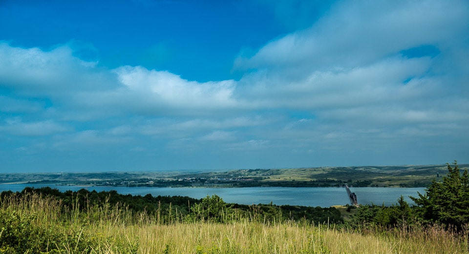
This is a view from a bluff over the Missouri at Chamberlain, South Dakota, hundreds of miles upriver from Council Bluffs. The river is much wider and wilder here, as the river has not been so channelled here as it has between Council Bluffs and Omaha, where the persistent flooding has been (almost) controlled by the Engineers.
I was in Chamberlain, SD, a few years ago and remember those beautiful vistas. You always take such fantastic photos of your journeys! Thanks for the memories!!
Your photos continue to amaze. Keep on clicking. In Amsterdam for 9 days with daughter and two grands. Great great city. Love to Kris.
Thanks, Dave. Badlands coming up.
I am longing to come home to Council Bluffs one more time.
And Janet, we’re longing to see you there.
I was born in Rapid City. My grandparents lived in Geddes and Tyndall, South Dakota. When traveling from R.C. to their houses, we would drive over the pre-Interstate U. S. 16 bridge at Chamberlain. It is a continuous truss bridge with a very interesting past.
Originally, the bridge was part of old U. S. 281 which snaked its way south from Platte, South Dakota down to Wheeler and back up the rugged landscape to the Nebraska border. This was before the construction and completion of Ft. Randall Dam near Pickstown. The dam was part of the Pick-Sloan Plan of six major main stem Missouri Basin dams. The dam was started in, I believe, 1949, and completed fully in 1954. When the dam site was selected, it was clear that Wheeler, South Dakota would be inundated. This was a major town on U. S. 281 and where a major truss bridge crossed the Missouri.
The town was given notice of vacating the site and much was moved: cemeteries, major buildings, houses, utilities–and the U. S. 281 bridge.
The bridge was needed to replace an aging structure at Chamberlain and was in good shape. So, the South Dakota Department of Highways made plans to move it to Chamberlain up river. After the impounded Lake Francis Case crept up on the Wheeler site and covered it under 100+ feet of water, all need for old U. S. 281 was abandoned. The highway survives only as partly paved (south of Platte) and down to a point where it coincides with another county paved highway to Geddes and SD 50 begins. From there, south, it winds precipitously down to the river with quite a few magnificent views along its gravel route to behold. At its end is the “Benge Creek/ N.Wheeler Recreation Area.” The old U. S. 281 has been re-named for N. Wheeler Road.
Meanwhile, U. S. 16 was getting a new bridge! My mom remembers driving across the Missouri River in the early 1950s when a pontoon bridge was the only means to cross at Chamberlain. However, by the mid-1950s, the old Wheeler Bridge was re-perched on new piers and began operation as the “U. S. 16 Missouri River Bridge.”
So, that’s the story!
Doug
Tom:
Forgot to mention:
. . . and U. S. 281? When Ft. Randall was completed, U. S. 18 and 281 were re-routed. They now intersect near Wagner, South Dakota and overlay across Ft. Randall Dam. U. S. 18 diverges from 281 a short distance across the western end of the dam westward and U. S. 281 goes directly south towards Spencer, Nebraska and O’Neil.
Doug
Thanks, Doug, for all that. I’m going to have to appoint you as official historian.